Hey, everyone! It has been a while since I've written a post here. However, there's a good reason why I'm reviving this blog temporarily. Starting this Sunday, on May 14th, I will participate on a two-week trip to the Great Plains as part of UNC Asheville's Severe Weather Field Experience (SWFEX). My department, Atmospheric Sciences, only offer this course once every four years so I had to sign myself up for this one! It is a requirement of this trip that I have to keep a journal, but that's okay. I want to share my experiences with all of you by making my journal public.
Before I leave Asheville with the rest of SWFEX group, there's a special event I need to attend first. I am happy to let you know that I am graduating from UNC Asheville (UNCA) this Saturday with Bachelor of Science in Atmospheric Sciences. It's bittersweet to know that my four years in this town is coming to an end, but I am also proud of myself for accomplishing a major goal of graduating from college. I've always wanted to become a meteorologist since I was a kid and receiving my diploma from UNCA will one of last steps I have to take before my dreams come true. I want to give a shoutout to my parents, my brother, the rest of my family, my friends, my classmates, and my professors for helping me along the way. Thank you!
With that said, by taking this course, I'm still an UNCA student for couple more weeks even after getting my degree. Weird, right? Okay, so several of us on SWFEX trip are keeping a blog and my professor is expecting some of us to go mainstream beyond our circle of family and friends. This trip has received lot of media attention in the past so, therefore, I'm assuming that not all of you know me so I'll give you a quick introduction to myself. My name is Kyle Noel. I'm now a meteorologist for hire still seeking for his first job. My hobbies include weather forecasting, tracking storms, taking photos with my Nikon (see Photos tab for more), keeping up with my St. Louis Cardinals, and going on adventures somewhere in Blue Ridge Mountains. Oh, and I'm also deaf with a cochlear implant on my left ear. I can talk a lot more about myself, but I'll hold back on that for future posts.
The reason why I'm going on this trip as part of SWFEX, beside the fact I'm hopelessly in love with anything in the sky, is it'll make one of my dreams a reality. Ever since I saw Storm Chasers on the Discovery Channel as a kid, I've always wanted to wander across the openness of the Great Plains in search for world's most violent display of nature. It also helped that I grew up in the rolling hills of Missouri, where thunder roars and tornado sirens shrieks each spring. Storms of my Midwestern boyhood left a long-lasting impression on me and fueled my passion for violent weather. It's not quite the same with summer thunderstorms that come through North Carolina and that's why I want to go back west to recapture the nostalgic feeling of pure power that storms of the west are capable of. I can explain in my future posts why storms out west are different than ones in North Carolina, but that's for another time. Armed with vast knowledge of the atmosphere, thanks to my time at UNCA, I am ready to go out and see a tornado for the first time!
FORECAST DISCUSSION (5-11-17):
Okay, in most of my posts going forward, I may include a discussion about weather conditions that we could expect to see during the SWFEX trip. I'll go ahead and start with the first one tonight, but I will try to take it easy with weather lingos and explain them if you don't know what I'm talking about.
Looking at a set of computer models, I am liking what I'm seeing to start off our trip. It's too far to break down what I'm looking at into many details, but it's not a bad idea to look at overall pattern to see if conditions will be favorable for severe weather or not. We will start with analysis at 500 millibar level (or 20,000 feet into the atmosphere). There's a nice upper level low embedded in a trough moving into the Pacific Northwest this weekend. This guy will be our big key for severe weather threats next week. Now, most models has this upper level low stalling over Rockies by spinning itself around over and over. Because of the trough camping over western United States, we will have a nice, consistent southwest flow over the Great Plains. It'll require a long explanation why this is a great thing if you're looking for severe weather, but since we're still more than five days away, I'll save it for another day. Long story short: I can see a string of days with active severe weather threat for week of May 14-20. Storm Prediction Center (which we'll visit on this trip) has already issued 15% probability of severe thunderstorms in central Kansas and central Oklahoma for May 16th with more days to come (Figure 1). We are arriving to our "base camp" of Norman, Oklahoma on May 15th so our first real shot of finding storms will be on May 16th. Thankfully, it doesn't look like we'll have to go far from Norman for this one as long as this pattern doesn't break down!
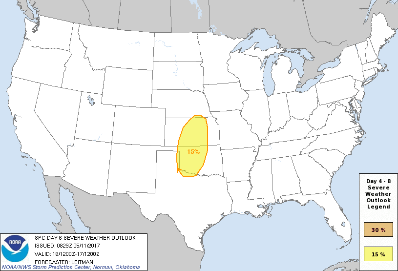
Figure 1: Storm Prediction Center's Day 6 Severe Weather Outlook. Seeing 15% probability of severe thunderstorms in yellow circle this far out is a good sign that we could have some fun on May 16th.
 RSS Feed
