
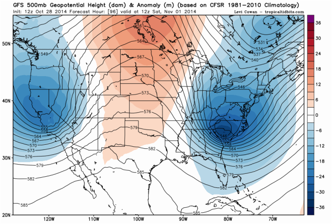
Well, it's that time of year again to start hunting for the first flake of the season here in Western North Carolina (WNC). In the past two years, according to Ray's Weather Center, the highest elevations in this area such as Sugar Mountain and Beech Mountain recorded their first measurable snow in the final week of October. However, it's starting to look like it'll not occur in October this year but we shouldn't wait too much longer after Halloween. Long-range models, such as European ECMWF and American GFS, has hinted at a powerful trough digging into Eastern United States for about a week now (Figure 1). As we get into short-range period, the trough is a guarantee at this point and it will bring in strong CAA (cold air advection) behind a major cold front traveling into southeastern states. As result, the cold will come flowing into the area for the weekend surface temperature will crash hard below freezing as soon as this Saturday morning for many locations across WNC. However, that's not even the most interesting part as a weak Miller B low will be present over the area at that same time bringing in some moisture. The result of below freezing temperature and moisture combo could signal the very first snow event of winter for mountain communities that Saturday morning, especially in higher elevation where temperatures are even colder.
(Figure 1: A major trough digging into Eastern USA, as shown here by GFS. Picture is courtesy of Levi Cowan of tropicaltidbits.com)
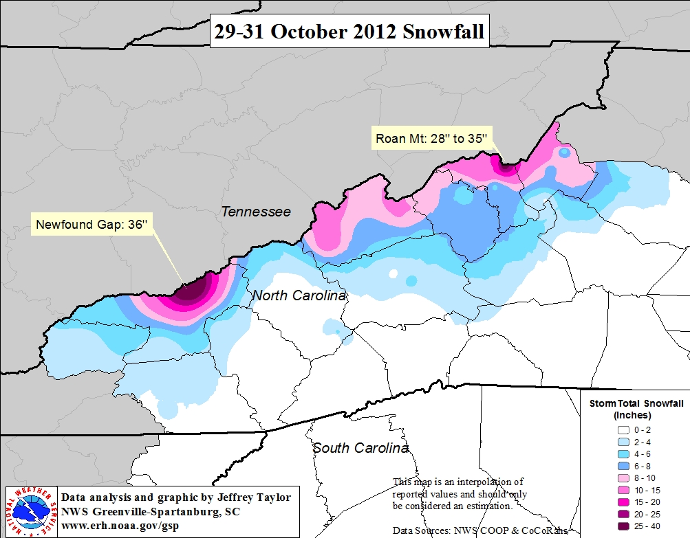
The problem is we got two very different solutions between ECMWF and GFS for those in lower elevations like cities of Boone and Asheville. As of this afternoon, GFS is favoring a much warmer surface temperature of 29°F to 33°F for valleys communities. 850 mb temperatures are also barely below 0°C (32°F) for the area and moisture is lacking outside NC/TN border mountains, and therefore, limits snow threat in valleys to couple of flakes that won't stick due to warm soil temperature. However, GFS does have a powerful north-northwest winds moving into NC/TN border mountains with lot of energy thanks to the location of trough. With the conditions slightly favorable among these ridges, strong winds carrying moisture from Great Lakes could slam into mountains and force the air to ascend up into colder conditions. This air will then condenses into precipitation and we get snow showers on mountain peaks. Even though soil temperature will be warm, the upsloping may become overwhelming enough to give few inches of snow to NC/TN border mountains. However, ECMWF solution is much more robust with snow threat in WNC. For one, temperatures are much cooler across the area at both surface and 850 mb levels. Most of WNC could see anywhere from 25°F to 30°F with 850 mb temperatures coming in between -2°C and -6°C if ECMWF verifies. There's also little bit more precipitation making it over NC/TN border ridges and into valleys thanks to little more energy than GFS is showing. The result of ECMWF solution is more mountain communities seeing few inches of snow with couple of mountain peaks getting large totals and maybe larger flakes in valleys, although soil temperature is still not favorable for anything more than light accumulation in many valley towns, including Asheville and Boone. Right now, I really like ECMWF solution a bit more due to higher skills in medium-range than GFS but it could be overdone at this time of year (especially snow maps on paid sites!). I'm expecting accumulation of few inches to mountains of NC/TN border with possible large totals at couple of peaks due to upsloping, but I can't really see anything more than flurries for rest of Western North Carolina. It'll get chilly in many places this weekend, but don't get too hopefully about seeing a whiteout. However, October 29-31, 2012 event (Figure 2) proved that nothing is impossible for widespread couple inches of accumulation this early in winter, especially if ECMWF completely verifies or if this upcoming event over-perform with the cold and moisture. Even though the event in 2012 was very unique, as it came from Hurricane Sandy to east, it's a good reminder that crazier things had happened.
(Figure 1: A major trough digging into Eastern USA, as shown here by GFS. Picture is courtesy of Levi Cowan of tropicaltidbits.com)
The problem is we got two very different solutions between ECMWF and GFS for those in lower elevations like cities of Boone and Asheville. As of this afternoon, GFS is favoring a much warmer surface temperature of 29°F to 33°F for valleys communities. 850 mb temperatures are also barely below 0°C (32°F) for the area and moisture is lacking outside NC/TN border mountains, and therefore, limits snow threat in valleys to couple of flakes that won't stick due to warm soil temperature. However, GFS does have a powerful north-northwest winds moving into NC/TN border mountains with lot of energy thanks to the location of trough. With the conditions slightly favorable among these ridges, strong winds carrying moisture from Great Lakes could slam into mountains and force the air to ascend up into colder conditions. This air will then condenses into precipitation and we get snow showers on mountain peaks. Even though soil temperature will be warm, the upsloping may become overwhelming enough to give few inches of snow to NC/TN border mountains. However, ECMWF solution is much more robust with snow threat in WNC. For one, temperatures are much cooler across the area at both surface and 850 mb levels. Most of WNC could see anywhere from 25°F to 30°F with 850 mb temperatures coming in between -2°C and -6°C if ECMWF verifies. There's also little bit more precipitation making it over NC/TN border ridges and into valleys thanks to little more energy than GFS is showing. The result of ECMWF solution is more mountain communities seeing few inches of snow with couple of mountain peaks getting large totals and maybe larger flakes in valleys, although soil temperature is still not favorable for anything more than light accumulation in many valley towns, including Asheville and Boone. Right now, I really like ECMWF solution a bit more due to higher skills in medium-range than GFS but it could be overdone at this time of year (especially snow maps on paid sites!). I'm expecting accumulation of few inches to mountains of NC/TN border with possible large totals at couple of peaks due to upsloping, but I can't really see anything more than flurries for rest of Western North Carolina. It'll get chilly in many places this weekend, but don't get too hopefully about seeing a whiteout. However, October 29-31, 2012 event (Figure 2) proved that nothing is impossible for widespread couple inches of accumulation this early in winter, especially if ECMWF completely verifies or if this upcoming event over-perform with the cold and moisture. Even though the event in 2012 was very unique, as it came from Hurricane Sandy to east, it's a good reminder that crazier things had happened.
(Figure 2: Map of October 29-31, 2012 event from NWS Greenville-Spartanburg)
DISCLAIMER: This blog is mostly for self-education and forecasting practices. This post is by no mean an official weather forecast from me or my university. For an official weather information regarding your location, please listen to your local TV meteorologist or look up on National Weather Service website. Thank you for reading! - Kyle
DISCLAIMER: This blog is mostly for self-education and forecasting practices. This post is by no mean an official weather forecast from me or my university. For an official weather information regarding your location, please listen to your local TV meteorologist or look up on National Weather Service website. Thank you for reading! - Kyle

 RSS Feed
