
Well, the year of 2015 is finally here. Other than a massive cold outbreak in January, a Category 2 hurricane ruining Fourth of July plans for many vacationing at our beaches, and a historical snowstorm for Western NC mountains on Halloween night, not really much has happened in North Carolina during 2014. Weather was remarkably average for the most part, although 2014 was cooler than the 1981-2010 average thanks to an epic January, a summer that ran cooler for a second straight year, and an early Arctic outbreak in November. It was also slightly wetter than average in Central NC, although still not as insanely wet as 2013 was. In the final few weeks of 2014, unseasonable warm temperatures torched the Southeast and gave us mostly mild weather with some rainstorms moving across our area thanks to an active subtropical jet stream due to an ongoing weak El Nino in Pacific. However, all of this is about to change very quickly if computer models are to be believed.
During the past few weeks, models were struggling badly to get any consistency going with the overall weather pattern in the long range (meaning 7-15 days out from today) and many busts occurred. Of course, long range forecasting isn't always an exact science, but it was insane to see many models flip-flopping between wintry and mild patterns every 12 hours. After Christmas, they finally settled with an idea of a warm pattern to kick off 2015 and that came through for the most part. However, in the past two days, models have suddenly flipped the switch and are currently suggesting an approaching cold pattern to finish off January with a brief warm-up in middle of it. I'm not going to bother with long range forecast past my birthday on January 11th on this post, but models finally found some consistency in medium range (4-7 days from today) with an idea of another near-historic Arctic outbreak rivaling to "Polar Vortex" of January 2014 by middle of next week. Oh, and for love of all things that is holy, please do not use the term "polar vortex" to describe the cold ever again.
During the past few weeks, models were struggling badly to get any consistency going with the overall weather pattern in the long range (meaning 7-15 days out from today) and many busts occurred. Of course, long range forecasting isn't always an exact science, but it was insane to see many models flip-flopping between wintry and mild patterns every 12 hours. After Christmas, they finally settled with an idea of a warm pattern to kick off 2015 and that came through for the most part. However, in the past two days, models have suddenly flipped the switch and are currently suggesting an approaching cold pattern to finish off January with a brief warm-up in middle of it. I'm not going to bother with long range forecast past my birthday on January 11th on this post, but models finally found some consistency in medium range (4-7 days from today) with an idea of another near-historic Arctic outbreak rivaling to "Polar Vortex" of January 2014 by middle of next week. Oh, and for love of all things that is holy, please do not use the term "polar vortex" to describe the cold ever again.
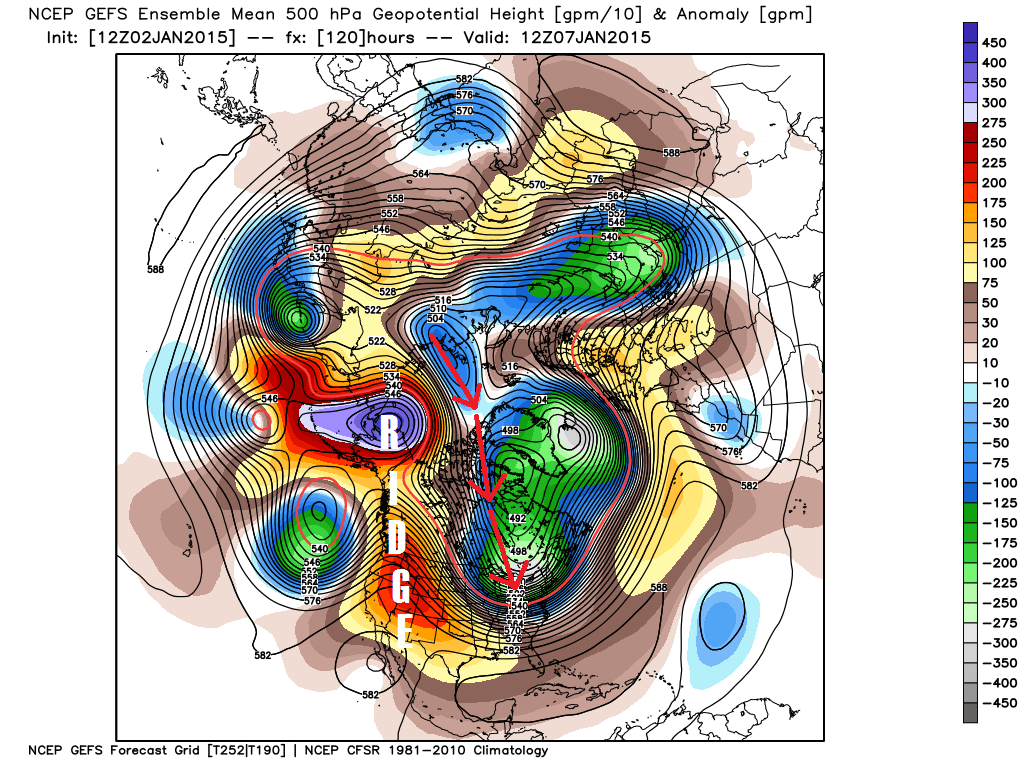
(Figure 1: 12z GFS ensemble forecast for 7 am January 7th showing massive "ridge" building up over Western North America and the direction of cold air mass from Siberia to East Coast. Source: WeatherBell modeling website.)
The easiest way to explain why I think a massive cold snap is happening for North Carolina is by showing y'all a map of Northern Hemisphere (Figure 1) from this morning's run of Global Forecasting System (GFS). Right now, a large area of high pressure, also known as "ridge," is currently over the Pacific Ocean. Because this ridge was hanging around in Pacific, there's was a trough over Western United States that gave desert areas like Las Vegas, Phoenix, and Southern California some snow. This also led to milder than usual weather in North Carolina the past few days with another ridge sitting over us. However, that's all about to change once the Pacific ridge moves into Western North America in the next few days as suggested by the models. This will allow a trough in Eastern North America and also set up a block over Alaska strong enough to force a polar jet stream all the way into Siberia, Russia, where some of the coldest air in Northern Hemisphere are located. The polar jet stream will then carry cold air parcels across the North Pole region from Siberia all the way to here in my small rural North Carolina town of Clayton over the next several days (Figure 2). From Russia with love, indeed.
The easiest way to explain why I think a massive cold snap is happening for North Carolina is by showing y'all a map of Northern Hemisphere (Figure 1) from this morning's run of Global Forecasting System (GFS). Right now, a large area of high pressure, also known as "ridge," is currently over the Pacific Ocean. Because this ridge was hanging around in Pacific, there's was a trough over Western United States that gave desert areas like Las Vegas, Phoenix, and Southern California some snow. This also led to milder than usual weather in North Carolina the past few days with another ridge sitting over us. However, that's all about to change once the Pacific ridge moves into Western North America in the next few days as suggested by the models. This will allow a trough in Eastern North America and also set up a block over Alaska strong enough to force a polar jet stream all the way into Siberia, Russia, where some of the coldest air in Northern Hemisphere are located. The polar jet stream will then carry cold air parcels across the North Pole region from Siberia all the way to here in my small rural North Carolina town of Clayton over the next several days (Figure 2). From Russia with love, indeed.
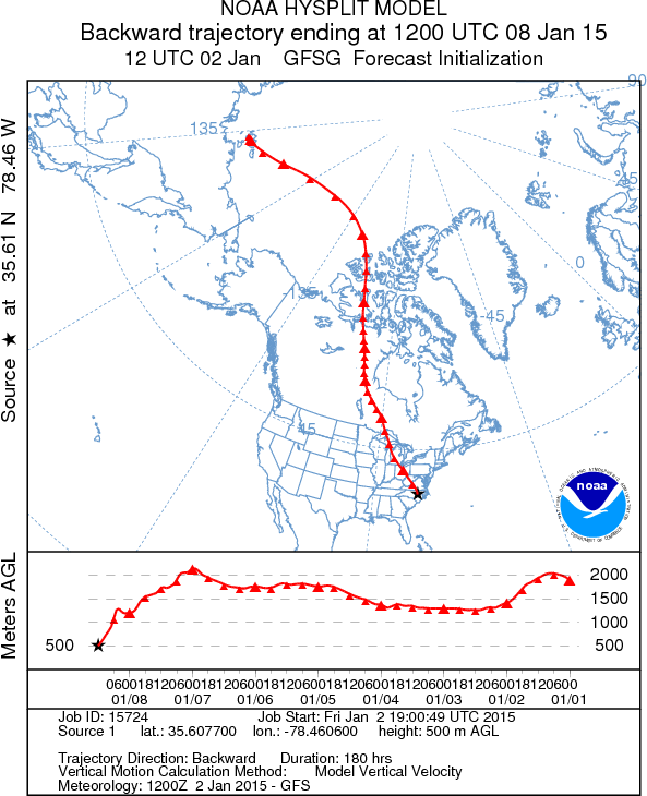
(Figure 2: NOAA HYSPLIT model showing extremely cold air parcel in Clayton, North Carolina on morning of January 8th is coming from all the way back to its January 1st location 2 kilometers above Siberia.)
Now that I explained why crazy cold is very possible by middle of next week, how cold are we exactly about in Central NC? Well, I don't think it'll get as cold as it did last year (Figure 3), but it'll get pretty close for most areas in North Carolina. Keep in mind we're still 6 days from Arctic cold blast event so this all might not happen, but strong consensus between American, Canadian, and European models is very hard to beat. In additional to that, ensembles tends to do well in medium range so confidence in extreme cold is high as of this moment. Temperatures forecast will tends little warmer over the next 6 days thanks to cold bias of extreme model solutions in medium, but most of North Carolina could face sub-freezing temperature for 42 hours from evening of January 7th to midday January 9th. Temperature could get below zero in mountains of Western NC, in single digits for those in Triad, and in low-teens for those in Triangle and Eastern NC as updated-GFS computer model is suggesting (Figure 4). European model is suggesting a even colder solution in Western NC while maintaining low-teens for folks in Triangle and Eastern NC. The high for the day of January 8th is likely not breaking out 20s for anyone in North Carolina (Figure 5). Again, cold bias of models in medium range could result in more realistic low of high-teens for us in Central NC at the lowest from this upcoming Arctic cold snap, but it could easily show colder solution over the next few days. We do have 6 days to figure out final temperature forecast for period of January 7th to 9th, so we will see what happens. Have a nice day!
Now that I explained why crazy cold is very possible by middle of next week, how cold are we exactly about in Central NC? Well, I don't think it'll get as cold as it did last year (Figure 3), but it'll get pretty close for most areas in North Carolina. Keep in mind we're still 6 days from Arctic cold blast event so this all might not happen, but strong consensus between American, Canadian, and European models is very hard to beat. In additional to that, ensembles tends to do well in medium range so confidence in extreme cold is high as of this moment. Temperatures forecast will tends little warmer over the next 6 days thanks to cold bias of extreme model solutions in medium, but most of North Carolina could face sub-freezing temperature for 42 hours from evening of January 7th to midday January 9th. Temperature could get below zero in mountains of Western NC, in single digits for those in Triad, and in low-teens for those in Triangle and Eastern NC as updated-GFS computer model is suggesting (Figure 4). European model is suggesting a even colder solution in Western NC while maintaining low-teens for folks in Triangle and Eastern NC. The high for the day of January 8th is likely not breaking out 20s for anyone in North Carolina (Figure 5). Again, cold bias of models in medium range could result in more realistic low of high-teens for us in Central NC at the lowest from this upcoming Arctic cold snap, but it could easily show colder solution over the next few days. We do have 6 days to figure out final temperature forecast for period of January 7th to 9th, so we will see what happens. Have a nice day!
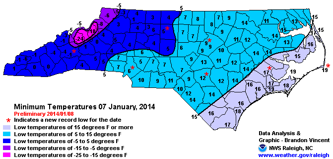
(Figure 3: Minimum temperatures of North Carolina from last year's Arctic cold outbreak on January 7th. This upcoming cold could rivals this event. Source: National Weather Service - Raleigh.)
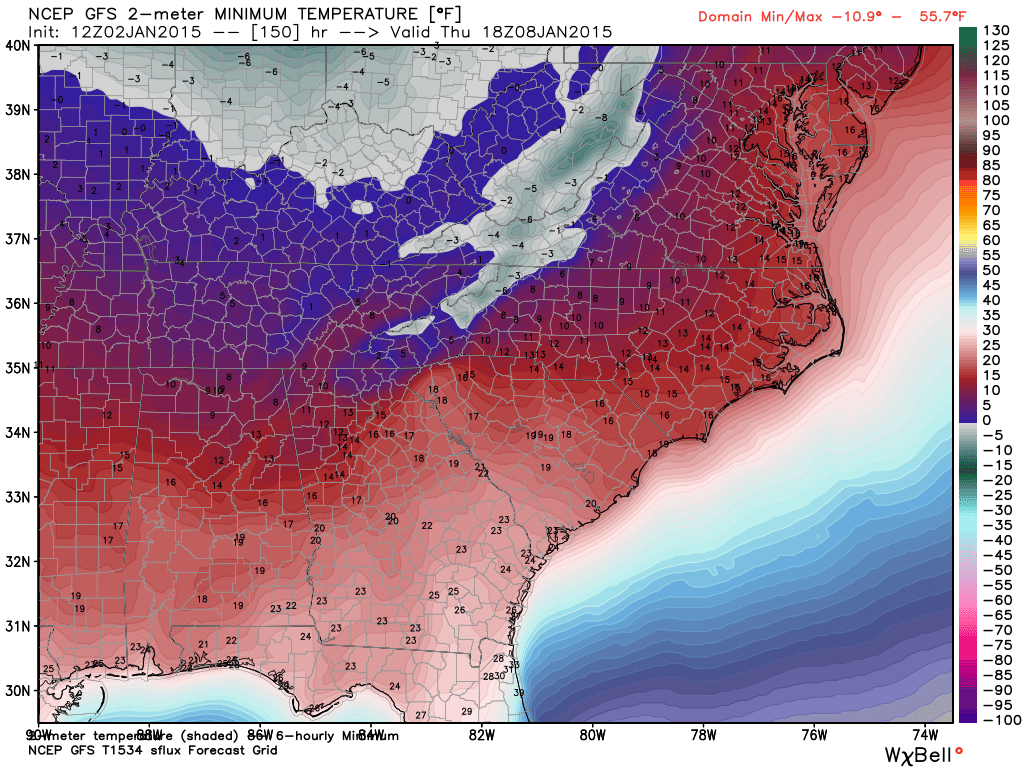
(Figure 4: Low temperatures for morning of January 8th from 12z GFS computer model. As you can see, the whole state is in mid-teens at the warmest. This is just an estimation of cold in 6 days from today rather than absolute forecast since lot can change in atmosphere between now and January 8th. Source: WeatherBell modeling website.)
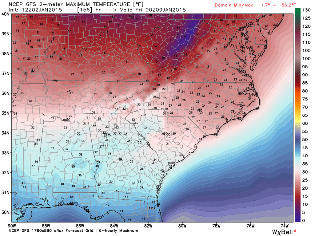
(Figure 5: High temperatures for day of January 8th from 12z GFS computer model. As you can see, most of North Carolina doesn't leave 20s the whole day. This is just an estimation of cold in 6 days from today rather than absolute forecast since lot can change in atmosphere between now and January 8th. Source: WeatherBell modeling website.)
DISCLAIMER: This blog is mostly for self-education and forecasting practices. This post is by no mean an official weather forecast from me or my university. For an official weather information regarding your location, please listen to your local TV meteorologist or look up on National Weather Service website. Thank you for reading! - Kyle
DISCLAIMER: This blog is mostly for self-education and forecasting practices. This post is by no mean an official weather forecast from me or my university. For an official weather information regarding your location, please listen to your local TV meteorologist or look up on National Weather Service website. Thank you for reading! - Kyle

 RSS Feed
