
I know this is coming at the last minute, but computer models weren't showing any significant chance of frozen precipitation until last night. Now, it appears that atmosphere is favorable for some freezing rain for those living among I-95 corridor in Eastern North Carolina. The first question you may be asking here: why freezing rain instead of snow? Well, allow me to explain using 12z 4 km-NAM sounding for Rocky Mount, NC as an example by using BUFKIT (Figure 1). One thing for sure is moisture will be present, as shown below with red temperature and green dew point line being close to merging together. In order to get all of this moisture into snow, entire atmosphere over the area must be below freezing temperature of 0°C/32°F! However, this is not the case with this event as there's some warm air aloft at 850 mb level (or about a mile above ground). This warm air aloft will melt any snow falling toward the ground, but there's a catch. Temperature could fall back to below freezing line again just a couple thousands feet above the ground and may not get any warmer than freezing line again on way to the ground. Since models are suggesting a thin sub-freezing layer at the surface in additional to the fact this warm air aloft will be very deep, any precipitation likely will not have enough time to turn rain back into frozen pellet, such as snow or sleet. However, the surface could be cold enough to freeze any moisture on ground into ice on contact. This is major reason why tonight's event is mostly freezing rain with some possibility of sleet if warm air aloft isn't as deep as models are showing.
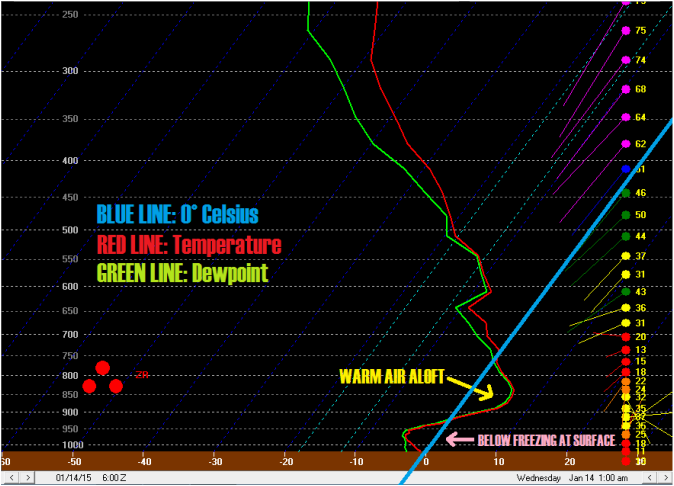
(Figure 1: 12z 4 km-NAM sounding for Rocky Mount, NC at 1:00 am tonight via BUFKIT program.)
Next thing is to figure out how much of tonight's precipitation will fall as regular or freezing rain. Most regular models earlier this morning had surface temperature dripping below freezing later this evening (around 10 pm) into tomorrow's morning, but there are some trends to keep an eye on. For one, short-range models, such as RAP and HRRR, are showing a delay in cold air arrival to Johnston County until around 3 in the morning. They are also trending a tad warmer at surface with minimum temperature tonight barely below freezing between 30°F to 32°F. Another thing to mention, as noted by National Weather Service in Raleigh in their area forecast discussion (AFD), is the fact radar over Georgia/South Carolina look extremely unimpressive. Regular models are in disagreement over total quantitative precipitation forecast (QPF) ranging from almost nothing to decent amount of moisture falling as much as 0.50-0.70 inch of moisture. I would say about half of tonight's precipitation will fall as freezing rain assuming it doesn't get too warm at surface and cold air doesn't get delayed any longer. This would bring us to ice total of around 0.25 inch at the heaviest, but I got my doubts due to recent trends in short-range models in additional to unimpressive radar scans over Georgia/South Carolina. For this event, I really like NWS Raleigh's forecast of 0.1-0.2 inch of ice for people of Johnston County at the most but it wouldn't surprise me if the county only see graze of ice on surface at most tomorrow's morning. Last thing to note: NCDOT announced earlier today that they will not put down any brine due to pre-event rain. Salt will only get washed away so it's useless to treat roads in the area. Just remember that even a graze of ice will make the roads slippery, so precautions are necessary while driving tomorrow morning no matter what!
DISCLAIMER: This blog is mostly for self-education and forecasting practices. This post is by no mean an official weather forecast from me or my university. For an official weather information regarding your location, please listen to your local TV meteorologist or look up on National Weather Service website. Thank you for reading! - Kyle

 RSS Feed
