Well, it has been a while since I blogged on here about a weather event. School got tougher after my previous post and I didn't feel like summarizing an event in few paragraphs when I can post a quick update on Facebook. However, I really want this make this blog useful as a place where I can express my thoughts on weather happenings and learn from it. Therefore, I'm going to give it an another try. And we do have something to talk about today!
Earlier this morning, University of Nebraska's United States Drought Monitor has released their weekly update for the whole country and it was a bit concerning for citizens of Western North Carolina. Almost the entire Foothills region is under moderate drought with few counties of Gaston, Lincoln, and Shelby getting severe drought status due to lack of rain last few months (Figure 1). Looking at Charlotte's weather observations, it's not hard to see why. As of July 29, Charlotte had received only 18.39 inches of rain comparing to 2000-2015 January-July precipitation mean of 24.81 inches on this box graph below (Figure 2). Charlotte's actual rain amount average for first seven months is 24.38 inches using 1981-2010 climate data, but even with that, Charlotte is still running around six inches behind for 2015. Doesn't sound much, but it's a huge deal for those in agriculture.
Earlier this morning, University of Nebraska's United States Drought Monitor has released their weekly update for the whole country and it was a bit concerning for citizens of Western North Carolina. Almost the entire Foothills region is under moderate drought with few counties of Gaston, Lincoln, and Shelby getting severe drought status due to lack of rain last few months (Figure 1). Looking at Charlotte's weather observations, it's not hard to see why. As of July 29, Charlotte had received only 18.39 inches of rain comparing to 2000-2015 January-July precipitation mean of 24.81 inches on this box graph below (Figure 2). Charlotte's actual rain amount average for first seven months is 24.38 inches using 1981-2010 climate data, but even with that, Charlotte is still running around six inches behind for 2015. Doesn't sound much, but it's a huge deal for those in agriculture.
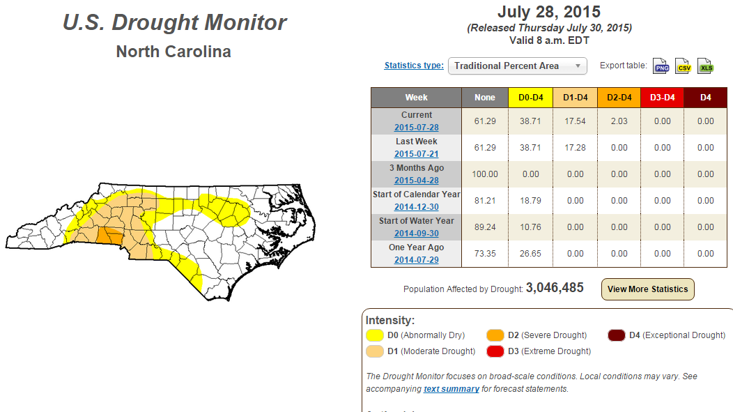
Figure 1: U.S. Drought Monitor map for North Carolina.
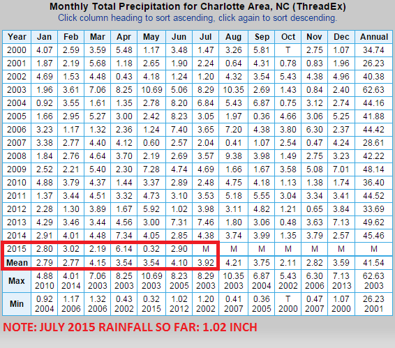
Figure 2: Monthly precipitation observations for Charlotte, NC from National Weather Greenville-Spartanburg office. July 2015 rainfall total is as of July 29th.
Almost all of us have heard about what's going in California so some of you might be panicking about our drought situation. However, what's happening in California is a whole different situation and I'm highly confident this is a short-term drought that will fade away during this upcoming winter thanks to a strengthening El Nino episode. During an El Nino event, equatorial waters of Eastern Pacific Ocean heats up a couple degrees warmer (in Celsius) leading to more rising air parcels. An increase in activity of parcels will lead to more convection in the region and this creates more energy and thunderstorms. Both get pick up by a streaking subtropical jet stream before journeying across Southern United States (Figure 3). This is why North Carolina's winter months are wetter during a strong El Nino year (Figure 4) and this will probably be the case in late-2015/early-2016. You can learn more about El Nino episodes from State Climate Office of North Carolina here.
Almost all of us have heard about what's going in California so some of you might be panicking about our drought situation. However, what's happening in California is a whole different situation and I'm highly confident this is a short-term drought that will fade away during this upcoming winter thanks to a strengthening El Nino episode. During an El Nino event, equatorial waters of Eastern Pacific Ocean heats up a couple degrees warmer (in Celsius) leading to more rising air parcels. An increase in activity of parcels will lead to more convection in the region and this creates more energy and thunderstorms. Both get pick up by a streaking subtropical jet stream before journeying across Southern United States (Figure 3). This is why North Carolina's winter months are wetter during a strong El Nino year (Figure 4) and this will probably be the case in late-2015/early-2016. You can learn more about El Nino episodes from State Climate Office of North Carolina here.
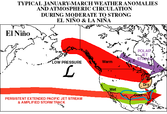
Figure 3: Typical atmospheric reaction to an El Nino episode during winter months. Note that North Carolina is cooler and wetter in this situation. Graphic from NOAA's Climate Prediction Center.
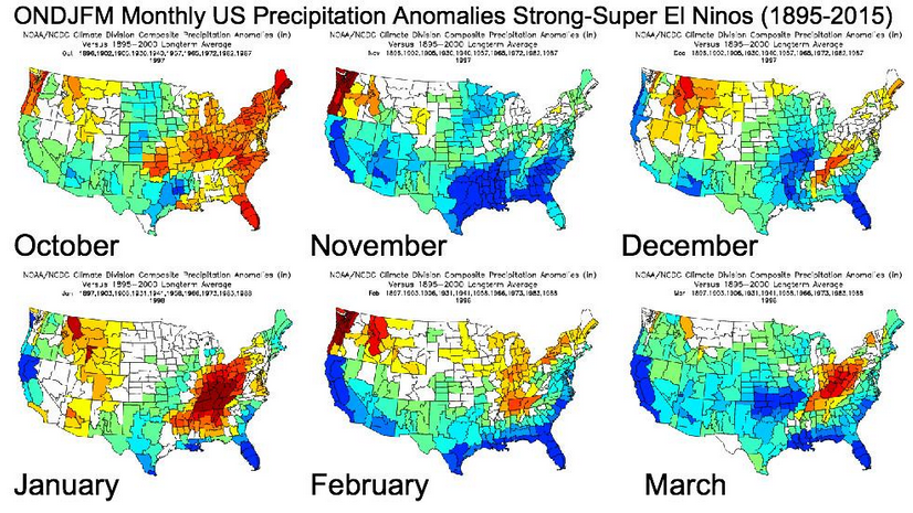
Figure 4: Anomaly graphic of United States' precipitation using eleven combined years of strong/super El Nino episodes between 1895-2000. As you can see, North Carolina is wetter during winter months of a strong/super El Nino year like winter of 2015-16 probably will be. This was created by NC State student, Eric Webb (Twitter account: @webberweather).
BOTTOMLINE: Western North Carolina's drought is getting little worse, but relief is coming in the next several months as result of a major El Nino episode in the Pacific.
BOTTOMLINE: Western North Carolina's drought is getting little worse, but relief is coming in the next several months as result of a major El Nino episode in the Pacific.

 RSS Feed
